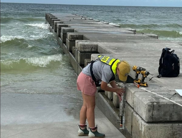
As Hurricane Milton approaches Florida, U.S. Geological Survey (USGS) scientists are deploying wave sensors at eight key locations between Naples and Crystal River to monitor coastal waves generated by the storm.
USGS field crews are also installing a rapid-deployment gauge on the Sunshine Skyway Bridge in St. Petersburg. This temporary streamgage will provide real-time water level data during the storm, helping decision-makers and emergency managers track rising water levels and respond quickly to protect lives and property.
READ: Hurricane Milton Explosively Intensifies, Expected To Be Category 5 Storm As It Eyes Florida
The National Hurricane Center has warned that Hurricane Milton could bring life-threatening storm surges and damaging winds to parts of the Florida Peninsula. The USGS wave sensors will measure critical data, such as wave height, frequency, and storm tide—a dangerous combination of storm surge and local tides. These storm tides can wreak havoc, destroying infrastructure, eroding landscapes, and disrupting essential services.
The sensors will remain in place throughout the storm, and once it’s safe, scientists will retrieve the data to help refine future storm surge models and improve coastal change forecasts. This information will also assist emergency responders and local officials in identifying the hardest-hit areas and guide recovery efforts. Additionally, the data may inform flood insurance maps and building codes to enhance public safety in future storms.
READ: Georgia Welcomes Hurricane Milton Evacuees With Travel Alert And Resources
The wave sensors, housed in durable aluminum pipes, are installed on bridges, piers, and other sturdy structures. Their placement aims to ensure survival through the storm and allow for the collection of valuable information.
Updates on the sensor deployments and rapid deployment gauge can be tracked on the USGS Flood Event Viewer. For residents in the storm’s path, preparedness tips are available at ready.gov or listo.gov to help families create emergency plans and assemble supply kits.
Please make a small donation to the Tampa Free Press to help sustain independent journalism. Your contribution enables us to continue delivering high-quality, local, and national news coverage.
Android Users: Download our free app to stay up-to-date on the latest news.
Connect with us: Follow the Tampa Free Press on Facebook and Twitter for breaking news and updates.
Sign up: Subscribe to our free newsletter for a curated selection of top stories delivered straight to your inbox.

