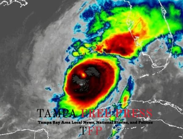
Hurricane Milton has strengthened into an extremely dangerous Category 4 hurricane with maximum sustained winds of 130 mph, posing an imminent threat to the west coast of Florida. Landfall is expected tonight, bringing life-threatening storm surge, damaging winds, and flooding rains to portions of central and southwestern Florida.
As of 2:00 PM EDT, the center of Milton was located about 130 miles west of Ft. Myers and 150 miles southwest of Tampa, moving north-northeast at 16 mph. A turn towards the northeast and a decrease in forward speed is anticipated this evening and tonight.
READ: Urgent Evacuation Order Issued For St. Petersburg As Flooding Begins
Watches and Warnings Expanded
Hurricane and Storm Surge Warnings are in effect for a large portion of Florida’s west coast, including Tampa Bay. Tropical Storm Warnings and Watches extend further north and south along the coast, and inland to Lake Okeechobee.
Life-Threatening Storm Surge
The NHC warns of a life-threatening storm surge, with the potential for water levels to reach 9-13 feet above ground in some areas. The highest surge is expected near and to the south of where the storm makes landfall.
READ: Hurricane Milton Update: Major Hurricane To Make Landfall Soon, Weakening Expected
Other Hazards
- Damaging Winds: Hurricane conditions are expected in the warning area, with tropical storm-force winds beginning in a few hours on the west coast.
- Flooding Rainfall: Rainfall amounts of 6 to 12 inches, with localized totals up to 18 inches, are possible across central and northern Florida, leading to catastrophic flash and urban flooding, as well as river flooding.
- Tornadoes: Several tornadoes are likely today and tonight across parts of central and southern Florida.
Urgent Call for Preparedness
Residents in the affected areas are urged to take the threat seriously and complete all preparations immediately. Heed all evacuation orders and warnings from local officials.
Key Messages:
- Evacuate if ordered: Life-threatening storm surge is a major danger. Do not attempt to ride out the storm in surge-prone areas.
- Prepare for hurricane conditions: Secure your property, gather supplies, and be ready for power outages.
- Be aware of flooding potential: Heavy rainfall could lead to widespread flooding. Stay informed and avoid flooded areas.
This is a dangerous and life-threatening situation. Stay informed and take all necessary precautions to protect yourself and your loved ones.
Please make a small donation to the Tampa Free Press to help sustain independent journalism. Your contribution enables us to continue delivering high-quality, local, and national news coverage.
Android Users: Download our free app to stay up-to-date on the latest news.
Connect with us: Follow the Tampa Free Press on Facebook and Twitter for breaking news and updates.
Sign up: Subscribe to our free newsletter for a curated selection of top stories delivered straight to your inbox.

