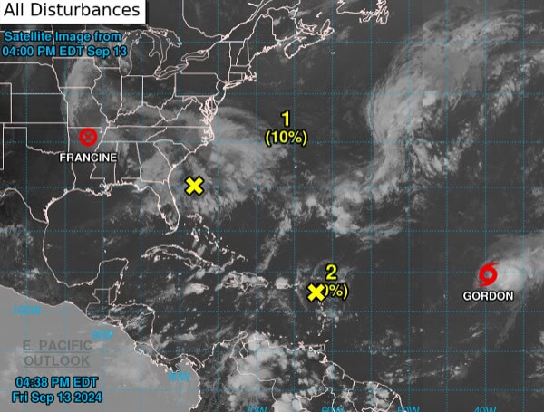
The National Hurricane Center (NHC) is tracking newly upgraded Tropical Storm Gordon in the central tropical Atlantic while closely monitoring two other weather systems that may develop over the next several days.
Tropical Storm Gordon
Tropical Storm Gordon, located over the central Atlantic Ocean, has recently strengthened and is now the subject of ongoing advisories from the NHC.
Post-Tropical Cyclone Francine
Meanwhile, the Weather Prediction Center continues to issue advisories on Post-Tropical Cyclone Francine, now situated inland over northeastern Arkansas.
Read: Florida Red Tide Update: No Presence Statewide
Potential System Off Southeastern U.S. Coast
Forecasters are also watching an area off the southeastern U.S. coastline where a non-tropical low-pressure system may develop along a frontal boundary this weekend.
While chances of formation remain low over the next 48 hours (10%), the system could gain subtropical or tropical characteristics early next week as it moves northwestward. The chance of development over the next seven days stands at 40%.
Low Pressure Near Northern Leeward Islands
An area of low pressure near the Northern Leeward Islands is currently producing limited shower activity. Environmental factors, including dry air, make development unlikely.
Formation chances are near 0% in the next 48 hours and over the next week.
Please make a small donation to the Tampa Free Press to help sustain independent journalism. Your contribution enables us to continue delivering high-quality, local, and national news coverage.
Android Users: Download our free app to stay up-to-date on the latest news.
Connect with us: Follow the Tampa Free Press on Facebook and Twitter for breaking news and updates.
Sign up: Subscribe to our free newsletter for a curated selection of top stories delivered straight to your inbox.


