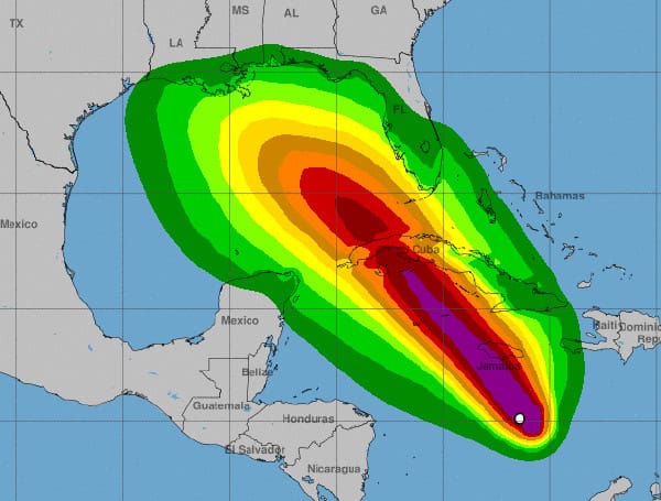
The seventeenth named storm of the 2024 Atlantic hurricane season has officially formed. The National Hurricane Center (NHC) has upgraded the disturbance in the Caribbean Sea to Tropical Storm Rafael.
Data from Hurricane Hunter aircraft indicate that Rafael is packing winds of 40 knots (about 46 mph).
Forecast Track and Intensification:
Tropical Storm Rafael is expected to continue strengthening as it moves northwestward, passing near Jamaica tonight and Tuesday, and then potentially impacting the Cayman Islands and western Cuba by midweek.
The storm is forecast to become a hurricane by Tuesday evening, bringing damaging winds, storm surge, and destructive waves to the Cayman Islands. Western Cuba and the Isle of Youth are also at increasing risk of dangerous storm surge and hurricane-force winds on Wednesday.
READ: AccuWeather Warns Of Potential Hurricane Threat To US Gulf Coast
After crossing Cuba, Rafael is expected to enter the Gulf of Mexico, but the long-range track and intensity forecast remains uncertain.
Potential Impacts:
- Jamaica: Tropical storm conditions are expected tonight and Tuesday, with heavy rain and potential flooding.
- Cayman Islands: Hurricane conditions are expected by Tuesday evening, with damaging winds and storm surge.
- Cuba: Hurricane conditions are possible for western Cuba, including the Isle of Youth, on Wednesday.
- Florida Keys: Tropical storm conditions are possible in the Lower and Middle Keys beginning late Wednesday or Wednesday night.
- Northern Gulf Coast: It is too early to determine the potential impacts on the northern Gulf Coast, but residents should monitor the storm’s progress closely.
Heavy Rainfall:
Heavy rain is expected across portions of the western Caribbean, including Jamaica and Cuba, through mid-week. Flooding and landslides are possible in these areas. The heavy rainfall could then spread into Florida and other parts of the Southeast U.S. by the latter half of the week.
Stay Informed:
The NHC will continue to issue advisories on Tropical Storm Rafael. Residents in potentially affected areas should stay informed about the storm’s progress and be prepared for potential impacts.
Please make a small donation to the Tampa Free Press to help sustain independent journalism. Your contribution enables us to continue delivering high-quality, local, and national news coverage.
Android Users: Download our free app to stay up-to-date on the latest news.
Connect with us: Follow the Tampa Free Press on Facebook and Twitter for breaking news and updates.
Sign up: Subscribe to our free newsletter for a curated selection of top stories delivered straight to your inbox.


