August 23, 2020
By: Staff Report
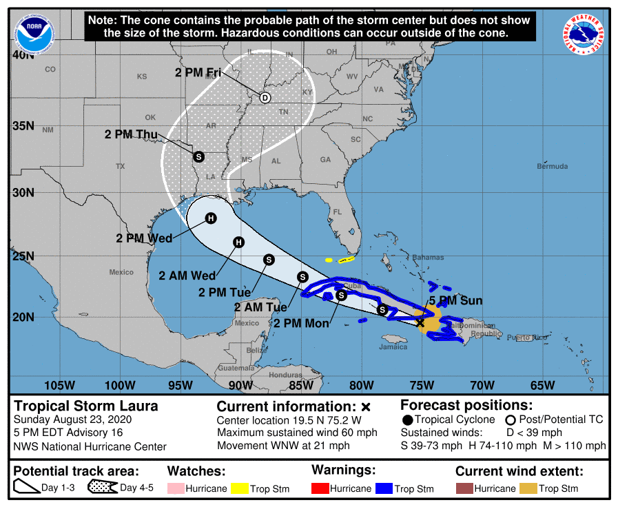
TAMPA, Fla. – Satellite imagery and radar data from eastern Cuba show that the center of Laura has been moving over water between Haiti and eastern Cuba this afternoon. There has been a recent uptick in convection near the center and the radar imagery has shown an increase in banding. According to the NWS, an Air Force reconnaissance aircraft investigating Laura this afternoon has reported a minimum pressure that has fallen to around 1000 mb, and winds to support an intensity of 50 kt.

Tropical storm conditions are expected across portions of Haiti, the southeastern Bahamas, and Cuba through Monday. Heavy rainfall is likely across Haiti, Cuba, and Jamaica through Monday and these rains could cause mudslides and life-threatening flash and urban flooding.
SUMMARY OF WATCHES AND WARNINGS IN EFFECT
A TROPICAL STORM WARNING IS IN EFFECT FOR:
- ENTIRE COAST OF THE HAITI
- INAGUA AND THE RAGGED ISLANDS IN SOUTHEASTERN BAHAMAS
- LITTLE CAYMAN AND CAYMAN BRAC
- CUBAN PROVINCES OF CAMAGUEY…LAS TUNAS…HOLGUIN…GUANTANAMO…
SANTIAGO DE CUBA…GRANMA…CIEGO DE AVILA…SANCTI SPIRITUS…
VILLA CLARA…CIENFUEGOS…MATANZAS…MAYABEQUE…LA HABANA…
ARTEMISA…PINAR DEL RIO…AND THE ISLE OF YOUTH
A TROPICAL STORM WATCH IS IN EFFECT FOR
- FLORIDA KEYS FROM CRAIG KEY TO KEY WEST AND THE DRY TORTUGAS

