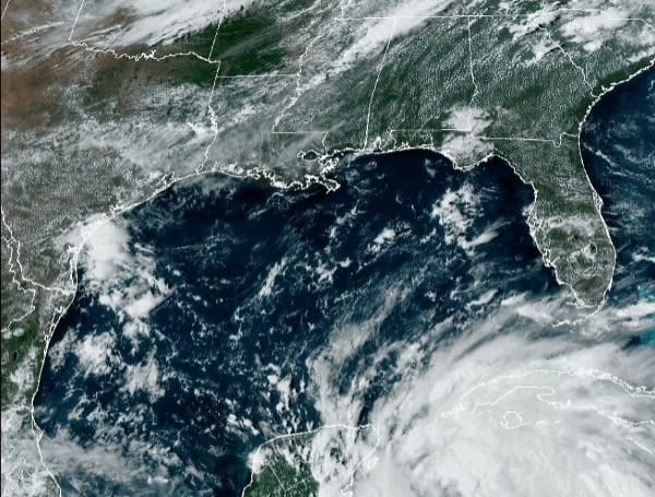
Tropical Storm Helene is rapidly intensifying, with maximum sustained winds now reaching 50 mph. The storm is projected to become a hurricane on Wednesday and further escalate into a major hurricane by Thursday as it traverses the eastern Gulf of Mexico. The storm’s large size is expected to cause widespread impacts across a vast area.
Watches and Warnings in Effect:
Read: Florida Gov. DeSantis Expands State Of Emergency To 61 Counties Ahead Of Hurricane Helene
A Storm Surge Warning is in effect for areas from Indian Pass to Flamingo, encompassing Tampa Bay and Charlotte Harbor. A Hurricane Warning has been issued for the region stretching from Anclote River to Mexico Beach in Florida, as well as from Cabo Catoche to Tulum in Mexico. A Hurricane Watch remains in place for the Cuban province of Pinar del Rio and from Englewood to Anclote River in Florida, including Tampa Bay.
Tropical Storm Warnings are in effect for various locations, including the Dry Tortugas, Lower and Middle Florida Keys west of the Channel 5 Bridge, Flamingo to Anclote River (including Tampa Bay), west of Mexico Beach to the Walton/Bay County Line, Rio Lagartos to Tulum in Mexico, and the Cuban provinces of Artemisa, Pinar del Rio, and the Isle of Youth. A Tropical Storm Watch has been issued for Lake Okeechobee and the area from the Palm Beach/Martin County Line northward to the Savannah River.
Read: Pasco County Schools Open Wednesday, Closed Thursday Due To Approaching Storm
Anticipated Impacts:
Helene is expected to produce heavy rainfall, potentially resulting in considerable flooding across western Cuba, the Cayman Islands, and the Yucatan Peninsula. The Southeastern U.S. could face significant flash, urban, and river flooding, with the possibility of landslides in the southern Appalachians. Life-threatening storm surge is also anticipated along Florida’s Gulf Coast, with potential inundation reaching up to 10-15 feet in some areas.
Read: Florida AG Ashley Moody Activates Price Gouging Hotline As Florida Braces For Hurricane Helene
Hurricane conditions are expected in Mexico on Wednesday and in the U.S. hurricane warning area late Thursday. Tropical storm conditions are likely to commence in Florida on Wednesday and extend northward through Thursday. Additionally, dangerous surf and rip currents are expected along the southern coast of Cuba, the Yucatan Peninsula, and will progressively affect the west coast of Florida and the northeastern Gulf Coast.
Watches and Warnings:
- Storm Surge Warning: Indian Pass to Flamingo, including Tampa Bay and Charlotte Harbor
- Hurricane Warning: Anclote River to Mexico Beach, Florida; Cabo Catoche to Tulum, Mexico
- Hurricane Watch: Pinar del Rio, Cuba; Englewood to Anclote River, including Tampa Bay
- Tropical Storm Warning: Dry Tortugas; Lower and Middle Florida Keys west of the Channel 5 Bridge; Flamingo to Anclote River, including Tampa Bay; West of Mexico Beach to the Walton/Bay County Line; Rio Lagartos to Tulum, Mexico; Artemisa, Pinar del Rio, and the Isle of Youth, Cuba
- Tropical Storm Watch: Lake Okeechobee; Palm Beach/Martin County Line northward to the Savannah River
Impacts:
- Rainfall: Helene is expected to bring heavy rainfall, potentially leading to considerable flooding in western Cuba, the Cayman Islands, and the Yucatan Peninsula. The Southeastern U.S. could experience significant flash, urban, and river flooding, with possible landslides in the southern Appalachians.
- Storm Surge: Life-threatening storm surge is expected along Florida’s Gulf Coast, with potential inundation of up to 10-15 feet in some areas.
- Wind: Hurricane conditions are expected in Mexico on Wednesday and in the U.S. hurricane warning area late Thursday. Tropical storm conditions are expected to begin in Florida on Wednesday and spread northward through Thursday.
- Surf: Dangerous surf and rip currents are expected along the southern coast of Cuba, the Yucatan Peninsula, and will spread towards the west coast of Florida and the northeastern Gulf Coast.
Additional watches or warnings may be issued for portions of Florida and the southeastern U.S. tonight or on Wednesday. Residents are urged to monitor updates from their local National Weather Service office and take necessary precautions.
