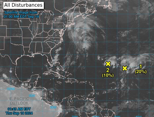
The National Hurricane Center (NHC) is monitoring three areas of potential development in the Atlantic basin, each with varying chances of forming into tropical depressions or storms in the coming days.
The first area of interest is the remnants of Gordon, currently located in the central tropical Atlantic. Although conditions are only marginally favorable for development, there is a low to medium chance (20% through 48 hours, 40% through 7 days) that a tropical depression or storm could re-form as the system moves north-northeastward over the next few days.
Read: Florida Gulf Coast Fishing Report – September 19, 2024
The second area is a well-defined low-pressure system located in the central and western subtropical Atlantic. This system has a low chance of development (10% through 48 hours, 20% through 7 days) but could still strengthen slightly as it moves over the open waters.
The third and final area to watch is in the northwestern Caribbean Sea and southeastern Gulf of Mexico. A broad area of low pressure could form here late this weekend or early next week. While development is not expected in the next 48 hours, the NHC gives this system a medium chance (40% through 7 days) of becoming a tropical depression as it moves north or northwestward through the middle of next week.
Read: FEMA Aid Available For Hillsborough County Residents Impacted By Hurricane Debby
The NHC will continue to monitor these systems and provide updates as necessary. It’s important for those in the potential impact areas to stay informed and be prepared for possible tropical weather development.
Please make a small donation to the Tampa Free Press to help sustain independent journalism. Your contribution enables us to continue delivering high-quality, local, and national news coverage.
Android Users: Download our free app to stay up-to-date on the latest news.
Connect with us: Follow the Tampa Free Press on Facebook and Twitter for breaking news and updates.
Sign up: Subscribe to our free newsletter for a curated selection of top stories delivered straight to your inbox.


