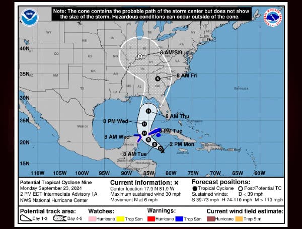
An Air Force Hurricane Hunter aircraft is currently investigating a disturbance in the Caribbean Sea, which is likely to become a tropical cyclone soon. The system is expected to strengthen into a hurricane as it moves into the Gulf of Mexico, potentially impacting the northeastern Gulf Coast by Thursday.
Current Status and Forecast
As of 2:00 PM EDT on September 23rd, the disturbance was located about 110 miles south-southwest of Grand Cayman. Maximum sustained winds are near 30 mph, with higher gusts. The system is moving north at 6 mph and is expected to turn northwestward on Tuesday, followed by a faster northward or north-northeastward motion on Wednesday and Thursday.
Read: AccuWeather Predicts Hurricane To Hit Florida Gulf Coast On Thursday
The center is forecast to cross the northwestern Caribbean Sea and enter the southeastern Gulf of Mexico in the next couple of days. Strengthening is anticipated, with the system likely becoming a hurricane on Wednesday and continuing to intensify as it moves across the eastern Gulf of Mexico.
Watches and Warnings
A Hurricane Watch is in effect for Cabo Catoche to Tulum, Mexico, and the Cuban province of Pinar del Rio. A Tropical Storm Warning is in effect for Rio Lagartos to Tulum, Mexico, and the Cuban provinces of Artemisa, Pinar del Rio, and the Isle of Youth.
Potential Impacts
Heavy rainfall is expected, with accumulations of 4 to 8 inches possible over western Cuba and the Cayman Islands, and 2 to 4 inches over the eastern Yucatan Peninsula. This could lead to flash and urban flooding, as well as minor river flooding. Heavy rainfall is also expected to spread into the southeastern U.S. from Wednesday through Friday.
Read: Are You Prepared As Potential Tropical Cyclone Threatens Florida Gulf Coast This Week?
Storm surge could raise water levels by 2 to 4 feet above normal tide levels in areas of onshore winds along the southern coast of Pinar del Rio, Cuba, and the east coast of the Yucatan Peninsula.
Hurricane conditions are possible within the watch areas by early Wednesday, and tropical storm conditions are expected in the warning areas beginning on Tuesday.
Residents in potentially affected areas are urged to monitor the progress of this system and follow any guidance from local officials.
Read: Pasco County Opens Sandbag Stations Ahead Of Potential Flooding
Please make a small donation to the Tampa Free Press to help sustain independent journalism. Your contribution enables us to continue delivering high-quality, local, and national news coverage.
Android Users: Download our free app to stay up-to-date on the latest news.
Connect with us: Follow the Tampa Free Press on Facebook and Twitter for breaking news and updates.
Sign up: Subscribe to our free newsletter for a curated selection of top stories delivered straight to your inbox.


