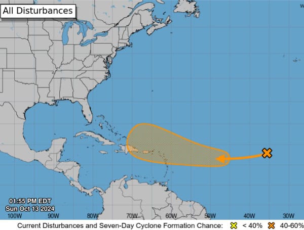
The National Hurricane Center is monitoring a disturbance in the eastern tropical Atlantic that has the potential to develop into a tropical depression later this week.
Currently, the system is a well-defined area of low pressure located several hundred miles west of the Cabo Verde Islands. While shower and thunderstorm activity is limited, and development is not expected in the next few days, conditions could become more favorable by the middle to latter part of the week.
READ: Lakeland Community Flooded In, Residents Plead For Help
The system is forecast to move west-northwestward, potentially approaching the Leeward Islands by the end of the week.
- Formation chance through 48 hours: Low (10 percent)
- Formation chance through 7 days: Medium (40 percent)
The National Hurricane Center will continue monitoring this system and the Tampa Free Press will be providing necessary updates.
Please make a small donation to the Tampa Free Press to help sustain independent journalism. Your contribution enables us to continue delivering high-quality, local, and national news coverage.
Android Users: Download our free app to stay up-to-date on the latest news.
Connect with us: Follow the Tampa Free Press on Facebook and Twitter for breaking news and updates.
Sign up: Subscribe to our free newsletter for a curated selection of top stories delivered straight to your inbox.


