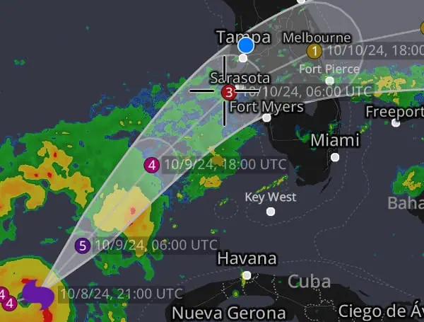
Hurricane Milton has rapidly intensified into an extremely dangerous Category 5 hurricane as it barrels towards Florida’s west-central coast. The latest reconnaissance mission by the Air Force Reserve Hurricane Hunters revealed that Milton’s central pressure has plummeted to 923 mb, indicating a significant strengthening of the storm.
Satellite imagery confirms this intensification, showing a well-defined eye surrounded by a thick ring of cold cloudtops.
Milton’s maximum sustained winds are now estimated at a staggering 145 kt (167 mph). While the storm wobbled slightly southeast earlier today, its overall movement is east-northeastward at 8 knots. Forecasters predict that Milton will turn northeastward and accelerate later today, setting it on a path to make landfall along Florida’s west-central coast sometime Wednesday night.
READ: Hurricane Milton Retains Strength After Eyewall Replacement, Florida Landfall Imminent
Landfall Location Still Uncertain
Although landfall is imminent, the exact location remains uncertain due to the possibility of further wobbles in the storm’s track. The National Hurricane Center (NHC) emphasizes that even at 36 hours out, their track forecasts can be off by an average of 60 nautical miles.
Prior to the latest NHC update, Milton’s eyewall pushed east and south of the original track; the track was corrected for this movement and now shows the center of the storm entering Sarasota. However, many factors could draw the storm center closer to Ft. Myers, which would bring catastrophic storm surge flooding to the Naples and Fort Myers area, or a slight jog north and the Tampa Bay area could see that impact.
Regardless, most of the state will feel the impacts of this monster storm.
READ: VIDEO: NOAA Aircraft Operations Rough Flight Through Hurricane Milton As It Eyes Florida
Major Hurricane Impacts Expected
Milton is expected to maintain major hurricane strength as it approaches and crosses Florida. While some weakening is possible due to increasing vertical wind shear, it is not expected to significantly diminish the storm’s intensity. The NHC warns of the following potential impacts:
- Life-Threatening Storm Surge: A destructive storm surge of 10 feet or greater is possible along portions of the west-central Florida coast.
- Devastating Winds: Hurricane-force winds will extend far inland, potentially causing widespread damage and power outages.
- Catastrophic Flooding: Heavy rainfall across the Florida Peninsula could lead to life-threatening flash flooding, urban flooding, and river flooding.
Urgent Call for Action
This is a very serious situation, and residents in the potentially affected areas are urged to take immediate action. Evacuations and all other preparations should be completed today.
Milton has the potential to be one of the most destructive hurricanes on record for west-central Florida. Residents should closely monitor the storm and follow all instructions from local emergency management officials.
Please make a small donation to the Tampa Free Press to help sustain independent journalism. Your contribution enables us to continue delivering high-quality, local, and national news coverage.
Android Users: Download our free app to stay up-to-date on the latest news.
Connect with us: Follow the Tampa Free Press on Facebook and Twitter for breaking news and updates.
Sign up: Subscribe to our free newsletter for a curated selection of top stories delivered straight to your inbox.

