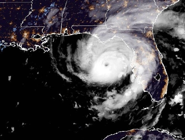
Hurricane Idalia is forecasted to be an “extremely dangerous” Category 4 storm at the time of its landfall on Wednesday morning.
This means it would have sustained winds of at least 130 mph and could cause catastrophic damage.
Originally, Idalia was predicted to intensify rapidly into a major Category 3 hurricane before reaching land. This indicates that the storm has been gaining strength quickly.
The predicted path of Hurricane Idalia has prompted the issuance of hurricane warnings and storm surge warnings for the Tampa Bay region.
As of 11 p.m. Tuesday, Idalia was situated approximately 125 miles west of Tampa. The storm was characterized by sustained winds of 110 mph, with stronger gusts. Its northward movement at 18 mph suggests it is on track to approach the Tampa Bay area.
In the news: Pasco County Evacuation Zone A: Time Is Running Out. Get To Higher Ground, Evacuate
Catastrophic impacts from storm surge inundation of 12 to 16 feet above ground level and destructive waves are expected somewhere between the Wakulla/Jefferson County line and Yankeetown, Florida. Life-threatening storm surge inundation is likely elsewhere along portions of the Florida Gulf Coast where a Storm Surge Warning is in effect.
Residents in these areas should follow any advice given by local officials.
There is the potential for destructive life-threatening winds where the core of Idalia moves onshore in the Big Bend region of Florida, with hurricane conditions expected elsewhere in portions of the Hurricane Warning area along the Florida Gulf Coast.
Strong winds will also spread inland across portions of northern Florida and southern Georgia near the track of the center of Idalia where Hurricane Warnings are in effect. Residents in these areas should be prepared for long-duration power outages. Damaging hurricane-force winds are possible in portions of eastern Georgia and southeastern South Carolina where Hurricane Watches are in effect.
In the news: Florida Gov. DeSantis Says It’s ‘Crunch Time’ For Hurricane Idalia
Areas of flash, urban, and moderate river flooding, with locally considerable impacts, are expected across the Florida Big Bend, central Georgia and South Carolina, through eastern North Carolina into Thursday.
Given the severity of the situation, it’s important for residents and authorities in the affected areas to closely monitor updates from reliable sources such as the National Hurricane Center (NHC) and follow any evacuation orders or safety recommendations that are issued. Stay safe and informed by staying tuned to official weather channels and local authorities’ instructions.
WATCHES AND WARNINGS IN EFFECT
Hurricane Warning:
- Middle of Longboat Key northward to the Indian Pass, including Tampa Bay
Storm Surge Warning:
- Englewood northward to the Indian Pass, including Tampa Bay
Tropical Storm Warning:
- Chokoloskee northward to the Middle of Longboat Key
- West of Indian Pass to Mexico Beach
- Sebastian Inlet Florida to South Santee River South Carolina
Hurricane Watch:
- Mouth of the St. Mary’s River to Edisto Beach South Carolina
Storm Surge Watch:
- Bonita Beach northward to Englewood, including Charlotte Harbour
- Mouth of the St. Mary’s River to South Santee River South Carolina
- Beaufort Inlet to Drum Inlet North Carolina
- Neuse and Pamlico Rivers North Carolina
Tropical Storm Watch:
- North of Surf City North Carolina to the North Carolina/Virginia border
- Pamlico and Albemarle Sounds
Android Users, Click To Download The Free Press App And Never Miss A Story. Follow Us On Facebook and Twitter. Signup for our free newsletter.
We can’t do this without your help; visit our GiveSendGo page and donate any dollar amount; every penny helps


