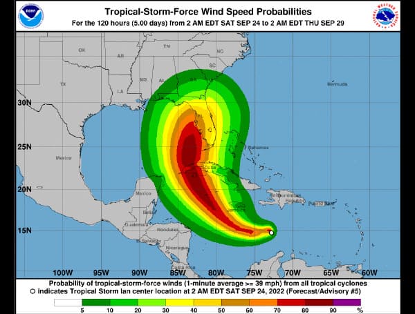
Tropical Storm Ian gained strength on Saturday morning and had 45 mph winds as it tracked westward in the central Caribbean.
The National Hurricane Center expects Ian to strengthen more — a lot more — and it could become a hurricane as soon as Sunday night.
It is forecast to move into the southeastern Gulf of Mexico on Tuesday and make a beeline for Florida’s west coast. Landfall could come by Wednesday or early Thursday, according to forecasters.
It could be a Category 2 or 3 hurricane by that point. The hurricane center’s official forecast track shows the center of the storm moving onshore on the west (or Gulf) side of the peninsula on Wednesday.
The hurricane center noted that forecast models have about a 180-nautical-mile spread in possible tracks for Ian at the 72-hour point, and the official forecast track has shifted westward slightly as of Saturday morning.
Ian is moving toward the west-southwest near 15 mph (24 km/h). A westward to west-northwestward motion is expected through early Sunday. A turn toward the northwest is forecast late Sunday, followed by a north-northwestward turn by late Monday.
On the forecast track, the center of Ian is forecast to move across the central Caribbean Sea today, pass southwest of Jamaica on Sunday, and pass near or over the Cayman Islands Sunday night and early Monday. Ian will then approach western Cuba on Monday.
Tropical-storm-force winds extend outward up to 45 miles (75 km) from the center.
Visit Tampafp.com for Politics, Sports, and National Headlines. Support journalism by clicking here to our GiveSendGo or sign up for our free newsletter by clicking here.
Android Users, Click Here To Download The Free Press App And Never Miss A Story. Follow Us On Facebook Here Or Twitter Here.
Copyright 2022 The Free Press, LLC, tampafp.com. All rights reserved. This material may not be published, broadcast, rewritten, or redistributed.


