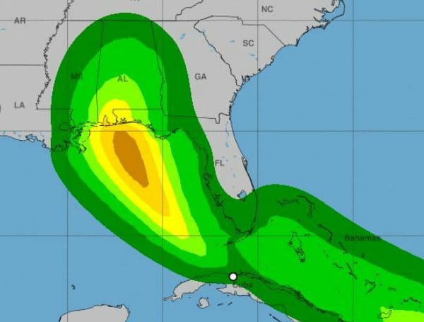
Tropical Depression Fred, located around 125 miles south-southwest of Key West, is moving west-northwest at 13 mph with sustained winds of 35 mph.
A turn to the northwest is expected by tonight, followed by a northward motion by Sunday night.
The three-day rainfall forecast for our area has decreased to just under an inch with the shift in track. Minor adjustments to the forecast track may occur.
Through Monday, 3 to 5 inches of rain with local amounts of 8 inches is anticipated across the Keys and southern Florida. Across the Florida Big Bend and Panhandle, 3 to 7 inches with isolated maximum totals of 10 inches are expected.
Heavy rainfall could lead to areal, urban, and small stream flooding impacts, and cause new minor flooding across the western Florida Peninsula and exacerbate ongoing minor to isolated moderate flooding in northern Florida.
From Monday onward, heavy rain and flood impacts could extend into
inland portions of the Southeast and into the southern and central
Appalachians and Piedmont as Fred interacts with a front in the
area.
A TROPICAL STORM WARNING IS IN EFFECT FOR…
- THE FLORIDA KEYS WEST OF THE SEVEN MILE BRIDGE TO THE DRY TORTUGAS
A TROPICAL STORM WARNING MEANS THAT TROPICAL STORM CONDITIONS ARE
EXPECTED SOMEWHERE WITHIN THE WARNING AREA…IN THIS CASE WITHIN THE
NEXT 24 HOURS.
INTERESTS IN CUBA AND IN THE FLORIDA PENINSULA AND FLORIDA
PANHANDLE SHOULD MONITOR THE PROGRESS OF FRED. WATCHES COULD BE
REQUIRED FOR PORTIONS OF THE FLORIDA PANHANDLE LATER TODAY.
Support journalism by clicking here to our gofundme or sign up for our free newsletter by clicking here
Android Users, Click Here To Download The Free Press App And Never Miss A Story. It’s Free And Coming To Apple Users Soon


