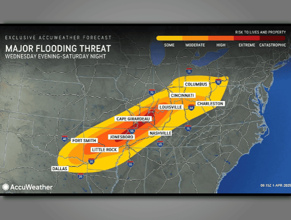
A significant weather event is unfolding across the central United States, with forecasters warning of the potential for historic flooding as rounds of torrential downpours are expected to persist through much of the weekend.
AccuWeather meteorologists are predicting that some areas could receive up to four months’ worth of rain in less than a week, with rainfall totals exceeding a foot in portions of Arkansas, Kentucky, and Ohio. This deluge raises the risk of rapid, major, and potentially unprecedented flooding.
The affected area is vast, with more than 46 million people in the path of the intense rainfall, and at least 13 million facing a high to extreme flood risk. Within these high-risk zones, the potential for catastrophic flooding exists in some communities.
READ: Senate Republicans Advance Budget Plan To Make Trump Tax Cuts Permanent
The heavy rain and resulting flooding began on Wednesday night and are expected to intensify daily.
The slow movement of the storm system, similar to a deadly event in February, is a major concern. While storm systems typically move quickly, a building zone of high pressure over the Southeast is blocking the normal west-to-east or northwest-to-southeast progression of this system, effectively trapping the storms over the central U.S.
This weather pattern is creating a “conveyor belt” of moisture, an atmospheric river originating from the Caribbean, which will fuel repeated rounds of torrential downpours and thunderstorms.
“That moisture plume, known as an atmospheric river, will be tropical in nature and originate from the Caribbean,” AccuWeather Senior Storm Warning Meteorologist William Clark said, “Tropical moisture raises the risk of excessive rainfall.”
The atmospheric river’s behavior will resemble that of a slow-moving tropical storm, but the repeated nature of the event could be akin to experiencing three or four tropical storms passing over the same area.
READ: Florida Fortune: $50 Lottery Scratch-Off Nets $1 Million Win
The sheer volume of rainfall, with the potential for up to four months’ worth to fall in five days along a 1,000-mile-long swath, is expected to overwhelm small streams and urban drainage systems. Rainfall rates of several inches per hour are possible, leading to rapid flash flooding.
“Should the amount of rain occur that we anticipate over the middle of the nation, it would exceed the 500 to 1,000-year average,” Clark said. “Truly, the potential is there for a historic flash flooding event.”
Residents in hilly terrain, particularly those living near small streams, are warned to be vigilant for rapidly rising water, which can pose a significant threat to vehicles and homes.
The floodwaters will eventually surge into larger rivers, leading to concerns about significant water level rises in major waterways such as the Ohio, Miami, Scioto, Wabash, White, St. Francis, Kentucky, and Tennessee rivers. The lower Mississippi River is also at risk of a surge due to the increased flow from the Ohio River.
The high, fast-moving water could disrupt tug and barge operations on the Mississippi River for several weeks.
READ: AccuWeather Warns Of Historic Flooding Threat And Severe Storms In Central US
Motorists, especially those using secondary roads, are strongly advised to be prepared to seek alternative routes due to potential road closures. Property owners are urged to take preventative measures and be prepared for possible evacuations in some areas.
It is noteworthy that NOAA’s river gauge forecasts initially underestimated the severity of the flooding, with many sites now predicting major flooding.
AccuWeather meteorologists are anticipating major flooding in the Ohio Valley basin and significant rises in the Mississippi River, with the potential for major to near-record flooding in secondary rivers in the region.
The severe weather threat extends beyond flooding, with the same weather setup also producing multiple days of severe thunderstorms and tornadoes in the Central states.
Please make a small donation to the Tampa Free Press to help sustain independent journalism. Your contribution enables us to continue delivering high-quality, local, and national news coverage.
Connect with us: Follow the Tampa Free Press on Facebook and Twitter for breaking news and updates.
Sign up: Subscribe to our free newsletter for a curated selection of top stories delivered straight to your inbox.

