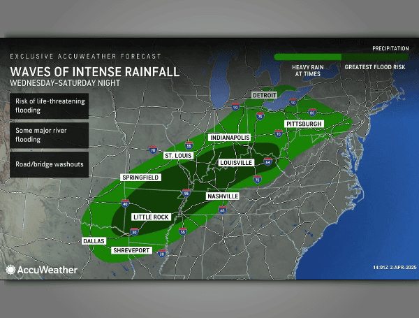
A rare and dangerous weather pattern is unleashing a barrage of life-threatening flash flooding and severe tornadoes across the central and eastern United States, with AccuWeather forecasters warning of “catastrophic” risks to lives and property. The relentless onslaught of storms, fueled by an atmospheric river from the Caribbean and Gulf, is expected to continue through the weekend, followed by a dramatic plunge in temperatures.
AccuWeather is issuing its strongest warning for flash flooding, a “catastrophic” risk, for parts of northeastern Arkansas, southeastern Missouri, southern Illinois, western Kentucky, and northwestern Tennessee. The last time such a severe warning was issued was during Hurricane Helene in September 2024.
READ: Central US Braces For Historic Flooding Amidst Severe Storms
“People across the region need to be prepared for a life-threatening flooding emergency,” cautioned AccuWeather Chief Meteorologist Jonathan Porter. “Relentless rounds of rainfall and back-to-back storms could quickly trigger catastrophic flooding. This is a rare and dangerous atmospheric setup.”
Forecasts predict 8-12 inches of rain across the affected areas through Saturday night, with some locations potentially seeing 12-18 inches, and an AccuWeather Local StormMax™ of 21 inches – equivalent to four months’ worth of rain in just five days. This deluge threatens to overwhelm creeks, streams, and rivers, including the Ohio, Wabash, Tennessee, Kentucky, White, and St. Francis, causing widespread disruptions to travel, business, and shipping.
“We could see several spots underwater for one to three weeks,” warned AccuWeather Senior Meteorologist Alex Sosnowski. “The biggest round of downpours from the atmospheric river will surge into the region on Saturday.”
READ: Decade Of Justice: MS-13 Gang Members Charged In Brutal Florida Murders
Adding to the danger, a “high risk” of severe thunderstorms and tornadoes is forecast for the Mississippi Valley and Gulf Coast states. Over 40 preliminary tornadoes and 280 damaging wind incidents have already been reported since Wednesday. The greatest tornado risk on Friday stretches from Texarkana to Little Rock and Cape Girardeau, with the threat expanding eastward on Saturday.
“We could see one to two dozen tornadoes Friday, including several powerful EF2 or EF3 tornadoes,” stated AccuWeather Chief On-Air Meteorologist Bernie Rayno. “Lifting warm fronts are notorious for producing tornadoes along and south of the warm front.”
The threat of severe storms, including tornadoes, damaging winds, and hail, will continue into Sunday and Monday, shifting eastward towards the East Coast.
Following the severe weather, an unseasonably cold air mass will surge into the region, bringing a hard freeze and potentially impacting cleanup and recovery efforts. Lake-effect snow is also possible downwind of the Great Lakes.
AccuWeather warns of potential extended power outages, leaving residents without electricity and heat for several days.
Please make a small donation to the Tampa Free Press to help sustain independent journalism. Your contribution enables us to continue delivering high-quality, local, and national news coverage.
Connect with us: Follow the Tampa Free Press on Facebook and Twitter for breaking news and updates.
Sign up: Subscribe to our free newsletter for a curated selection of top stories delivered straight to your inbox.

