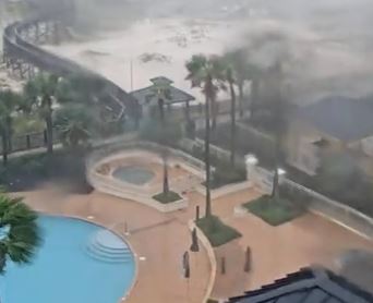
MOBILE, ALABAMA – Historic life-threatening flash flooding due to rainfall is likely through Wednesday along and just inland of the coast from the Florida Panhandle west of the Apalachicola River to far southeastern Mississippi. Widespread moderate to major river flooding is forecast along and just inland of the central Gulf Coast. Significant flash and urban flooding, as well as widespread minor to moderate river flooding, is likely across inland portions of Mississippi and Alabama, and into Georgia and the western Carolinas this week.
Life-threatening storm surge is expected along portions of the coastline from Alabama to the western Florida Panhandle, including Mobile Bay.
Hurricane conditions are expected this evening and overnight within portions of the Hurricane Warning area along the Mississippi and Alabama coastlines and the western Florida Panhandle.
SUMMARY OF WATCHES AND WARNINGS IN EFFECT…
A STORM SURGE WARNING IS IN EFFECT FOR…
- MOUTH OF THE MISSISSIPPI RIVER TO THE OKALOOSA/WALTON COUNTY LINE
FLORIDA - MOBILE BAY
A HURRICANE WARNING IS IN EFFECT FOR…
- EAST OF BAY ST. LOUIS TO NAVARRE FLORIDA
A TROPICAL STORM WARNING IS IN EFFECT FOR…
- EAST OF NAVARRE FLORIDA TO INDIAN PASS FLORIDA
- BAY ST. LOUIS WESTWARD TO GRAND ISLE LOUISIANA
