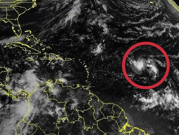
The National Weather Service (NWS) is closely monitoring a weather system in the Atlantic, designated AL94, for potential tropical development. If it strengthens, it will be named Tropical Storm Nadine.
Spaghetti models suggest AL94 is likely to track northwest, passing north of Antigua and Barbuda, towards the Dominican Republic and Cuba. From there, it could turn southwest towards Jamaica or, less likely, continue northwest towards Florida or the Gulf of Mexico.
While Florida is still recovering from recent hurricanes Milton and Helene, forecasters warn that AL94 could become a tropical depression or storm later this week as it approaches the Caribbean.
Factors at Play:
- Warm Water: Abnormally warm Atlantic waters, which fueled Hurricanes Beryl, Debby, and Helene, could contribute to AL94’s development.
- Dry Air: Currently, AL94 is embedded in a dry air environment, hindering immediate development.
- Late Season: The system’s late-season timing makes a westward track towards Texas less likely due to prevailing winds.
READ: Hurricane Milton Insured Losses Soar Past $586 Million In Florida, Expected To Reach Billions
Probabilities:
- The NWS gives AL94 a 10% chance of forming in the next 24 hours and a 60% chance within the next seven days.
Forecasters emphasize the uncertainty of the track and intensity, but urge vigilance as AL94 moves westward.
Please make a small donation to the Tampa Free Press to help sustain independent journalism. Your contribution enables us to continue delivering high-quality, local, and national news coverage.
Android Users: Download our free app to stay up-to-date on the latest news.
Connect with us: Follow the Tampa Free Press on Facebook and Twitter for breaking news and updates.
Sign up: Subscribe to our free newsletter for a curated selection of top stories delivered straight to your inbox.


