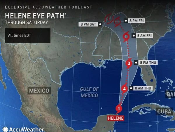
AccuWeather meteorologists are forecasting that Hurricane Helene will rapidly intensify into a powerful Category 4 hurricane before making landfall on Florida’s Big Bend region Thursday night. This storm has the potential to cause devastating impacts across a wide area.
“Helene is expected to rapidly grow into a very large and powerful hurricane. The threat of storm surge along the Big Bend of Florida is life-threatening and destructive,” warned AccuWeather Lead Hurricane Expert Alex DaSilva. “Serious impacts will be felt hundreds of miles away from the center of circulation.”
The storm’s effects will extend far beyond its center, with a broad area of 40-60 mph winds expected across most of Florida and into the Southeast.
Read: AccuWeather Warns Florida Hurricane Helene Could Grow To Catastrophic Category 4 Storm
“Helene has the potential to become a once-in-a-generation storm,” warned AccuWeather Chief Meteorologist Jon Porter. “People in the path of this storm need to be prepared for power outages hundreds of miles away from where Helene makes landfall that could last for a week or more.”
Potential for Catastrophic Flooding
DaSilva predicts a storm surge of 15-20 feet in parts of the Big Bend region and 6-10 feet in parts of the Tampa Bay area. He emphasizes the extreme risk of a devastating storm surge and urges residents to heed evacuation orders and move away from the coast.
“Water is the deadliest threat in a hurricane. There is an extreme risk of a devastating storm surge. Please follow evacuation orders and get away from the coast,” warned DaSilva.
Read: Florida AG Ashley Moody Activates Price Gouging Hotline As Florida Braces For Hurricane Helene
AccuWeather forecasts 8-12 inches of rainfall across the Big Bend and Tallahassee regions, with 12-18 inches in western parts of the Carolinas.
Senior Director of Forecasting Operations Dan DePodwin warns of potentially catastrophic flooding in the Southeast, particularly in the higher terrain of northern Georgia and the Carolinas, due to the combination of heavy rainfall both ahead of and during the storm.
Read: Hurricane Debby: Florida Agricultural Production Losses Top $93M, UF Economists Estimate
The steep terrain of the southern Appalachians is particularly vulnerable to mudslides and rockslides, which could isolate communities. The possibility of spin-up tornadoes also exists on the eastern side of the storm track across parts of Florida, Georgia, and South Carolina on Thursday, expanding north on Friday.
“The inland rainfall risk from Helene is significant. We could see catastrophic flooding across the southern Appalachians. We’ve already seen plenty of rain across Atlanta into the western Carolinas ahead of Helene. We’re concerned about significant flooding once this storm moves into Georgia and pushes north,” said DePodwin. “There is an extreme risk to lives and property in the southern Appalachians.”
Residents in the storm’s path are urged to follow evacuation orders, prepare for power outages, and take all necessary precautions to ensure their safety.
Please make a small donation to the Tampa Free Press to help sustain independent journalism. Your contribution enables us to continue delivering high-quality, local, and national news coverage.
Android Users: Download our free app to stay up-to-date on the latest news.
Connect with us: Follow the Tampa Free Press on Facebook and Twitter for breaking news and updates.
Sign up: Subscribe to our free newsletter for a curated selection of top stories delivered straight to your inbox.


