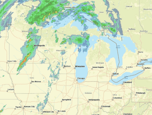
Millions across the Upper Midwest are under alert as a Tornado Watch has been issued for parts of Iowa, Minnesota, and South Dakota through Monday night. The looming threat of severe weather, including the potential for strong tornadoes, large hail, and damaging winds, has prompted officials to urge residents to take immediate preparedness measures.
The National Oceanic and Atmospheric Administration’s (NOAA) Storm Prediction Center (SPC) issued the Tornado Watch as supercell thunderstorms begin to develop across the region.
READ: Florida Anglers Reel In Record-Breaking Red Snapper Season For 2025
These powerful storms have the capability of producing very large hail, destructive wind gusts, and strong, potentially long-track tornadoes. The highest risk for these dangerous tornadoes is expected to persist into Monday evening.
More than 45 million people from Texas to the Upper Midwest are facing the risk of severe weather today. This follows a day of intense storm activity in the Plains, where a dramatic video captured a massive wedge tornado tearing across the landscape near Bingham and Ashby, Nebraska, on Sunday. Another video showed a train derailment in the same area due to the tornado’s powerful winds.
In anticipation of the severe weather, the City of Minneapolis issued a warning on Sunday, urging residents to prepare for the incoming extreme conditions.
Officials in Edina echoed this warning, with the Edina Police and Fire Departments posting on X, “Prepare now. Identify storm shelter locations, fully charge cell phones and backup batteries, have multiple ways to receive National Weather Service Warnings, and secure outdoor objects, such as furniture and trash cans.”
READ: Mexico Delivers Water To Texas, Steps Taken To Meet 1944 Treaty Obligations
The SPC highlights that all severe weather threats are possible with the developing thunderstorms, including the risk of large hail exceeding two inches in diameter and destructive wind gusts.
The threat of strong tornadoes (EF-2 or higher) is particularly elevated across portions of Minnesota, Iowa, and Wisconsin, impacting over 12 million people in cities such as Minneapolis and St. Paul, Minnesota; Madison, Wisconsin; Des Moines, Iowa; and Rockford, Illinois.
The severe weather threat is not isolated to Monday, as a multiday pattern will extend into Tuesday. Over 65 million people from Texas to the Northeast will be at risk of severe weather on Tuesday.
READ: UPDATE: One Dead, 10 Injured In Clearwater Ferry Crash; Hit-And-Run Boat Identified
The highest threat, however, will shift eastward, centering from central Ohio into western Pennsylvania and western and central New York, where the SPC has issued a Level 3 out of 5 risk. This zone includes approximately 11.5 million people in cities like Columbus and Cleveland, Ohio; Pittsburgh, Pennsylvania; and Rochester, New York.
Residents in the affected areas are strongly encouraged to stay informed of the latest weather updates, have a plan in place, and be prepared to seek shelter if warnings are issued.
Please make a small donation to the Tampa Free Press to help sustain independent journalism. Your contribution enables us to continue delivering high-quality, local, and national news coverage.
Connect with us: Follow the Tampa Free Press on Facebook and Twitter for breaking news and updates.
Sign up: Subscribe to our free newsletter for a curated selection of top stories delivered straight to your inbox.

