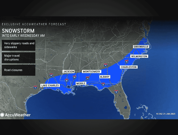
A rare and historic winter storm is wreaking havoc across the Gulf Coast, bringing dangerous blizzard conditions, record-breaking snowfall, and treacherous ice accumulation from eastern Texas through the Florida Panhandle. AccuWeather forecasts predict 3-6 inches of snow across the region, with an AccuWeather Local StormMax™ of 14 inches in isolated areas.
Travel along the Interstate 10 corridor has become extremely hazardous, with conditions expected to deteriorate further between Houston and New Orleans, extending into the Florida Panhandle.
“This is a rare, extremely disruptive and dangerous southern winter storm,” said AccuWeather Chief Meteorologist Jonathan Porter. “Snow and ice are accumulating in places that have not seen wintry weather in many years.”
READ: Plows Incoming: Florida Gov. DeSantis Warns Parts Of The State Could See 6″ Of Snow
The first-ever blizzard warning for southwestern Louisiana was issued for Lake Charles, where wind gusts of 35 mph or greater have reduced visibility to less than a quarter mile for several hours.
Impacts Across the Region
- Snowfall Accumulation:
- 3-6 inches expected from eastern Texas to Florida Panhandle
- 6-12 inches possible along I-10 in Louisiana and Mississippi
- AccuWeather Local StormMax™ of 14 inches in isolated areas
- Ice Accumulation:
- Up to an inch of ice from the Gulf Coast through northern Florida
- Jacksonville, Florida, could see significant ice buildup, leading to potential power outages
AccuWeather experts warn that Florida’s 1954 record of 4 inches of snowfall in 24 hours could be in jeopardy, with forecasts predicting up to 6 inches in parts of the state.
The storm has resulted in widespread road closures, including highways, bridges, and ramps across the affected regions. Over 1,400 flight cancellations are anticipated through Friday. Authorities urge residents to avoid travel unless absolutely necessary.
READ: Historic Winter Storm Threatens Travel Chaos, Power Outages From Florida To Texas
“If drivers get stranded in these dangerous conditions, they could be stuck for hours in the snow and cold,” warned AccuWeather Meteorologist Alex DaSilva.
The extreme cold following the storm is expected to complicate recovery efforts. Subfreezing temperatures will persist, increasing the risk of:
- Burst pipes in poorly insulated homes
- Hypothermia and frostbite due to prolonged exposure
- Power outages due to ice-laden tree branches falling on power lines
Authorities advise residents to prepare for potential power outages, as demand for heating is expected to surge.
The storm is expected to continue through Tuesday night into Wednesday morning, impacting early commuters across the Southeast. By midday Wednesday, it will move off into the Atlantic. AccuWeather forecasts 3-6 inches of snow for parts of the Outer Banks in North Carolina as the storm progresses.
Residents are encouraged to monitor weather updates through AccuWeather and local emergency management agencies for the latest alerts and advisories. Additional information on storm impacts and preparedness can be found at AccuWeather’s website.
Please make a small donation to the Tampa Free Press to help sustain independent journalism. Your contribution enables us to continue delivering high-quality, local, and national news coverage.
Connect with us: Follow the Tampa Free Press on Facebook and Twitter for breaking news and updates.
Sign up: Subscribe to our free newsletter for a curated selection of top stories delivered straight to your inbox.


