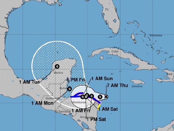
The National Hurricane Center (NHC) reports that Tropical Depression Nineteen has strengthened overnight, showing improved satellite imagery and structure. The depression now has sustained winds of 30 knots (35 mph), supported by data from the Indian Oceansat scatterometer, confirming a well-defined circulation.
Tropical Depression Nineteen is currently tracking west-southwest at a speed of 14 knots (16 mph), steered by a mid-level ridge to its north. The system is expected to continue on a westward path today, approaching the northern coast of eastern Honduras by Friday.
Over the weekend, the depression is forecast to slow down significantly due to weak steering currents, potentially stalling near the coast and leading to prolonged rainfall over Central America.
READ: Red Tide Detected In Southwest Florida
Forecast Track and Intensity
The NHC predicts that by early next week, a ridge developing over Florida and the eastern Gulf of Mexico will push the system northwestward across Belize and the Yucatan Peninsula.
The latest forecast shows a slight westward adjustment beyond three days, but uncertainty remains high due to possible land interaction.
Environmental conditions are favorable for the system to strengthen, with low wind shear and high humidity.
READ: Major Hurricane Developing In The Caribbean: Florida On Alert For Potential Impacts
However, the depression’s proximity to Honduras may hinder its development if it moves inland. If it stays offshore, as suggested by some models, including the HWRF, the depression could intensify rapidly. The NHC’s forecast currently keeps the system near hurricane strength as it nears the coast.
Key Messages
- Heavy Rainfall and Flooding Risk: The system is expected to bring heavy rainfall through early next week, leading to life-threatening flash flooding and mudslides in parts of Central America, particularly Honduras, Belize, El Salvador, eastern Guatemala, and western Nicaragua.
- Hurricane and Tropical Storm Alerts: The depression is forecast to approach the eastern coast of Honduras on Friday and Saturday, potentially near hurricane strength. Hurricane watches and tropical storm warnings have been issued for affected areas.
- Threat to Belize and Yucatan Peninsula: By early next week, the system is expected to reach the Belize coast and the Yucatan Peninsula of Mexico at or near hurricane strength, posing a risk of dangerous storm surge and damaging winds. Residents in these areas should closely monitor the latest updates and prepare their hurricane plans.
- Potential Impact to the Eastern Gulf of Mexico: It is still too early to determine the full impact on areas like the eastern Gulf of Mexico, Florida, the Florida Keys, and Cuba. Residents in these regions should stay informed with regular updates as the forecast evolves.
Please make a small donation to the Tampa Free Press to help sustain independent journalism. Your contribution enables us to continue delivering high-quality, local, and national news coverage.
Android Users: Download our free app to stay up-to-date on the latest news.
Connect with us: Follow the Tampa Free Press on Facebook and Twitter for breaking news and updates.
Sign up: Subscribe to our free newsletter for a curated selection of top stories delivered straight to your inbox.


