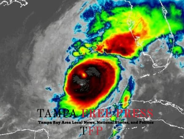
Hurricane Milton, currently a Category 4 storm with sustained winds of 125 mph, is barreling towards Florida’s west coast, posing a significant threat of life-threatening storm surge, destructive winds, and heavy rainfall. The storm is expected to make landfall tonight, bringing with it a potentially devastating impact to the region.
Milton’s structure has begun to change due to increasing southwesterly wind shear, causing the storm to weaken slightly. However, it is still predicted to be a major hurricane (Category 3 or 4) at landfall. Forecasters warn that even a slight wobble in the storm’s track could significantly alter the location and intensity of the worst impacts.
READ: Florida Governor DeSantis Provides Update On State Preparations For Hurricane Milton
“This is a very serious situation,” the National Hurricane Center (NHC) warned in its latest advisory. “Residents in Florida should closely follow orders from their local emergency management officials. Evacuations and other preparations should be completed over the next couple of hours.”
Storm Surge a Major Concern
The NHC predicts a large area of destructive storm surge, with the highest inundations of 10 feet or greater, along a portion of the west-central coast of Florida. Tampa Bay is particularly vulnerable, and residents in surge-prone areas have been urged to evacuate immediately.
“The time to evacuate, if told to do so by local officials, is quickly coming to a close,” the NHC emphasized.
Destructive Winds and Heavy Rainfall Expected
Hurricane-force winds are expected along portions of the west coast of Florida, where a Hurricane Warning is in effect. Even inland areas could experience life-threatening hurricane-force gusts as Milton crosses the Florida Peninsula. Residents are urged to prepare for long-duration power outages.
Heavy rainfall is also a major concern, with the potential for catastrophic flash and urban flooding, as well as moderate to major river flooding. The combination of coastal and inland flooding could exacerbate the overall flood threat.
READ: Tampa Bay Bridges To Close Wednesday Afternoon As Hurricane Milton Approaches
Uncertainty in Landfall Location
While the storm’s general track is northeastward, the exact landfall location remains uncertain. Even small deviations in the track can have a significant impact on where the worst surge and wind impacts occur.
“NHC’s track forecasts can be off by an average of 20-30 nautical miles,” the advisory noted. “This means that the realized storm surge heights across the Tampa Bay region and south may vary widely.”
Residents Urged to Take Action
With time running out, residents in the path of Hurricane Milton are urged to take the threat seriously and complete their preparations immediately. Heeding evacuation orders, securing property, and having a plan for long-duration power outages are crucial for staying safe during this dangerous storm.
Please make a small donation to the Tampa Free Press to help sustain independent journalism. Your contribution enables us to continue delivering high-quality, local, and national news coverage.
Android Users: Download our free app to stay up-to-date on the latest news.
Connect with us: Follow the Tampa Free Press on Facebook and Twitter for breaking news and updates.
Sign up: Subscribe to our free newsletter for a curated selection of top stories delivered straight to your inbox.


