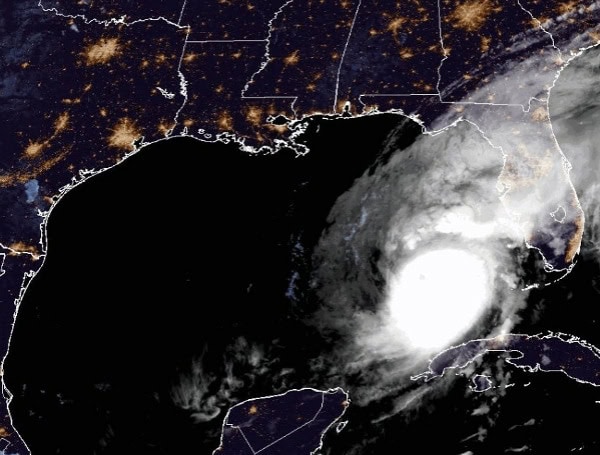
Hurricane Milton continues to maintain its strength as a powerful Category 5 storm in the southeastern Gulf of Mexico, with maximum sustained winds of 160 mph (140 knots) and a minimum central pressure of 907 mb. Satellite and radar data indicate the hurricane’s inner core remains compact, symmetric, and extremely strong.
The storm’s wind field is gradually expanding, and heavy rain is already spreading across southwestern and west-central Florida ahead of its arrival, with conditions expected to worsen throughout the day.
Read: Hurricane Milton’s Fury To Unleash On Florida: Major Hurricane To Make Landfall Within 24 Hours
Milton is currently tracking northeast at 14 mph (12 knots), driven by a mid-to-upper-level trough over the northern Gulf of Mexico and a ridge over the Greater Antilles. This motion is expected to continue until the hurricane reaches Florida’s west coast, with landfall likely late tonight or early Thursday morning.
Afterward, Milton is forecast to turn east-northeast as another trough approaches, moving across the state and exiting over the Atlantic by Thursday afternoon.
The National Hurricane Center (NHC) has slightly adjusted the forecast track northward based on the latest model guidance. However, residents are advised not to focus solely on the exact point of landfall, as the storm’s effects will extend far beyond the center.
While some weakening is expected due to increasing wind shear later today, Milton is forecast to remain a dangerous hurricane upon landfall and maintain hurricane strength as it crosses Florida. The storm is expected to transition to an extratropical cyclone over the Atlantic on Friday, gradually weakening. Milton’s wind field will continue to grow as it moves across the state, with widespread tropical storm and hurricane-force winds expected on the northwest side due to its interaction with a frontal boundary.
Residents should brace for significant impacts, including damaging winds, life-threatening storm surge, and heavy rainfall. Authorities are urging Florida residents to complete preparations and evacuate if ordered. The storm has the potential to be one of the most destructive hurricanes on record for west-central Florida.
Warnings and Watches in Effect:
- Storm Surge Warning: From Flamingo to Yankeetown on Florida’s west coast, including Charlotte Harbor, Tampa Bay, Sebastian Inlet, and Altamaha Sound, Georgia.
- Hurricane Warning: For areas including Bonita Beach to the Suwannee River and from the St. Lucie/Martin County line to Ponte Vedra Beach.
- Hurricane Watch: Includes Dry Tortugas, Lake Okeechobee, and stretches from Chokoloskee to Bonita Beach.
- Tropical Storm Warning: For the Florida Keys, Dry Tortugas, and extending along the eastern Florida coast and parts of the northwestern Bahamas.
- Storm Surge Watch: Extends from Altamaha Sound, Georgia to Edisto Beach, South Carolina.
Residents are advised to prepare immediately and follow local evacuation orders.
Forecast and Impacts:
- Storm Surge: Life-threatening storm surge of 10-15 feet is expected along the Florida coast, especially in areas south of landfall, with surge heights of 8-12 feet in Tampa Bay, Charlotte Harbor, and surrounding regions.
- Rainfall: Central and northern Florida could see 6-12 inches of rain, with localized totals up to 18 inches. This may result in severe flash flooding and river flooding.
- Wind: Hurricane conditions are expected this evening across Florida’s west coast, with tropical storm conditions spreading eastward and northward. Strong winds will extend well beyond the storm’s center.
- Tornadoes: Tornadoes are likely across central and southern Florida today and tonight.
- Surf: Swells generated by Milton will create hazardous surf and rip currents along the Gulf Coast and southeastern U.S.
Please make a small donation to the Tampa Free Press to help sustain independent journalism. Your contribution enables us to continue delivering high-quality, local, and national news coverage.
Android Users: Download our free app to stay up-to-date on the latest news.
Connect with us: Follow the Tampa Free Press on Facebook and Twitter for breaking news and updates.
Sign up: Subscribe to our free newsletter for a curated selection of top stories delivered straight to your inbox.


