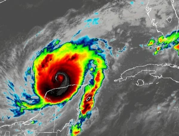
Hurricane Milton, a major hurricane currently churning through the Gulf of Mexico, has undergone some internal shifts while maintaining its status as a significant threat to Florida’s west coast. The storm is projected to make landfall Wednesday night, bringing with it the triple threat of destructive winds, life-threatening storm surge, and torrential rainfall.
Overnight, Milton experienced an eyewall replacement cycle, a common occurrence in intense hurricanes where the storm’s inner core reorganizes. While this process can sometimes weaken a hurricane, Milton has defied expectations and appears to have retained its intensity, potentially even emerging more organized.
Hurricane Hunter aircraft, braving the storm’s fury, have recorded winds of 156 knots (180 mph) within the eyewall, confirming Milton’s strength as a major hurricane. The storm’s central pressure, a key indicator of its intensity, is estimated to be a dangerously low 929 mb.
Currently, Milton is tracking east-northeast at a speed of 8 knots. Forecasts indicate that it will shift more towards the northeast and pick up speed today, placing it on a direct path to collide with Florida’s west-central coast.
While landfall is anticipated Wednesday night, the exact location remains somewhat uncertain. Even with the relatively short timeframe, the hurricane’s track could deviate by as much as 60-70 nautical miles. This uncertainty underscores the importance of preparedness across a wider area.
READ: Sarasota County Expands Evacuation Order As Hurricane Milton Intensifies
A significant and dangerous storm surge, potentially reaching 10 feet or higher, is expected along parts of the west-central Florida coast. This surge poses a severe threat to life and property, prompting urgent calls for residents in vulnerable areas to heed evacuation orders without delay.
Devastating hurricane-force winds are anticipated near and to the right of the hurricane’s center at landfall. These powerful winds will extend far inland, potentially causing widespread damage and power outages, disrupting daily life for a significant period.
In addition to the wind and surge, torrential rainfall is forecast across the Florida Peninsula. This deluge could lead to flash flooding in urban areas and potentially cause rivers to overflow, further compounding the dangers posed by the storm.
READ: Pinellas County Opens More Shelters as Hurricane Milton Approaches, Mandatory Evacuations In Effect
This is a critical situation with life-threatening potential. Residents in west-central Florida must take this storm seriously and adhere to the guidance provided by local officials. Evacuation orders should be followed promptly, as time is of the essence. Residents should also secure their properties and prepare for extended power outages that could disrupt essential services. Staying informed about the latest forecasts and updates from the National Hurricane Center and local news sources is crucial for everyone’s safety.
Hurricane Milton has the potential to become a historic and devastating storm for Florida. Residents must prioritize their safety and take all necessary precautions to protect themselves and their loved ones.
Please make a small donation to the Tampa Free Press to help sustain independent journalism. Your contribution enables us to continue delivering high-quality, local, and national news coverage.
Android Users: Download our free app to stay up-to-date on the latest news.
Connect with us: Follow the Tampa Free Press on Facebook and Twitter for breaking news and updates.
Sign up: Subscribe to our free newsletter for a curated selection of top stories delivered straight to your inbox.

