Expert meteorologists at AccuWeather are urging residents along Florida’s upper Gulf Coast to prepare immediately for Hurricane Helene, which is expected to bring life-threatening storm surge, destructive winds, flooding, and tornadoes within the next 48 hours.
“We’re urging people to get away from the immediate coastline and follow evacuation orders by local officials. We’re expecting deadly storm surge in parts of the Big Bend region. If you get caught in this storm surge in the hardest-hit areas, rescue crews likely will not be able to respond during the height of the storm. It’s too dangerous,” warned AccuWeather Lead Hurricane Expert Alex DaSilva. “This hurricane is expected to be quite large. Impacts will be widespread.”
Helene was officially named a tropical storm on Tuesday morning, and AccuWeather was the first source to issue a forecast track and intensity prediction on Sunday. The storm is expected to intensify rapidly due to exceptionally warm Gulf waters.
“This is another classic case of homegrown development. We have less than 72 hours between the point when the developing storm is officially named and when it makes landfall as a powerful hurricane,” said AccuWeather Chief On-Air Meteorologist Bernie Rayno. “Homegrown development leaves people with less time to prepare. These water temperatures are high octane, it’s like pouring gasoline on a fire.”
Rapid Intensification and Dangerous Conditions
AccuWeather Chief Meteorologist Jon Porter explained that water temperatures in the Gulf are 4 to 6 degrees warmer than the historic average, with some areas hitting record highs.
“Water temperatures are 4 to 6 degrees warmer than the historic average in many parts of the Gulf. There are some pockets with record-shattering temperatures right now,” said Porter. “Helene is forecasted to track right through areas with the warmest water temperatures in the Atlantic basin reaching hundreds of feet below the surface. Rapidly intensifying hurricanes can bring greater impacts at landfall. That’s why we’re so concerned about storm surge.”
Meteorologists are closely monitoring the tides as Helene approaches landfall, expected on Thursday. While the storm’s speed could help mitigate some of its impact by pushing strong winds farther inland, the rapid movement combined with high winds will still create widespread damage.
Wind gusts near landfall could reach 120-130 mph, with an AccuWeather Local StormMax™ of 160 mph. Strong winds will extend across much of the Southeast as Helene moves inland, potentially downing trees and power lines, causing widespread power outages.
Flooding and Heavy Rain
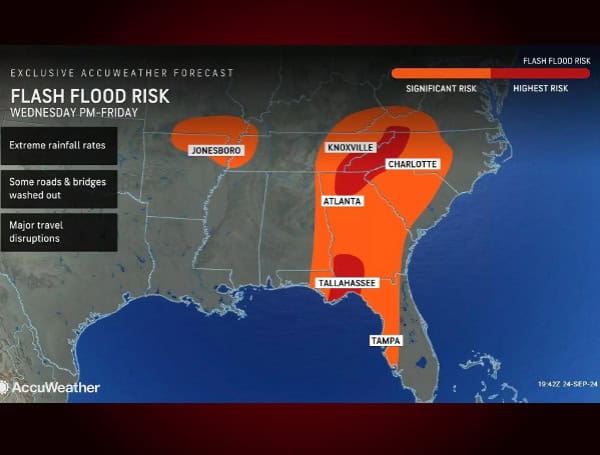
Rainfall totals are forecasted to reach 8-12 inches near Helene’s landfall, with an AccuWeather Local StormMax™ of 24 inches. Heavy rains will lead to flash flooding, particularly in the Florida Panhandle, parts of Georgia, and the Carolinas. Rapid rainfall, combined with high winds, could overwhelm drainage systems and lead to significant, life-threatening flooding.
“Helene could cause catastrophic flooding, especially in the higher terrain of northern Georgia, upstate South Carolina, and western North Carolina,” said Porter. “Mudslides and rockslides are also a risk, and some communities may be cut off due to damage to roads and bridges.”
Storm Surge and Tornado Threats
A storm surge of 6-10 feet is expected from north of Tampa Bay to east of Apalachicola, with a devastating surge of 10-15 feet likely east of the Big Bend region. This poses a significant threat to lives and property in the area.
Additionally, Helene could spawn tornadoes as it moves inland. These tornadoes, often forming with little warning, can add to the storm’s overall destruction, particularly during nighttime hours.
Widespread Power Outages and Travel Disruptions
AccuWeather forecasts widespread power outages, especially in the Tallahassee region and across the Southeast, as far north as southwest Virginia. The storm is also expected to cause major travel disruptions, with an estimated 750 flight cancellations on Thursday, 1,300 on Friday, and 500 on Saturday.
Please make a small donation to the Tampa Free Press to help sustain independent journalism. Your contribution enables us to continue delivering high-quality, local, and national news coverage.
Android Users: Download our free app to stay up-to-date on the latest news.
Connect with us: Follow the Tampa Free Press on Facebook and Twitter for breaking news and updates.
Sign up: Subscribe to our free newsletter for a curated selection of top stories delivered straight to your inbox.


