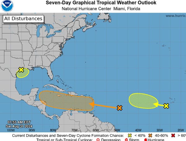
The National Hurricane Center (NHC) is monitoring three potential development areas. Two tropical waves are moving through the Atlantic, and another is in the Gulf of Mexico, according to the NHC, and they all have the possibility of developing.
A broad area of low pressure lingers near the upper Texas coast, bringing disorganized showers and thunderstorms to the coastal areas of Texas and Louisiana. This system is expected to remain near the coast for much of next week.
Read: Labor Day Weekend Fishing Report – Florida Gulf
Some slow development is possible if it moves offshore, but heavy rains could lead to flash flooding in coastal Louisiana and upper Texas regardless of development.
The formation chance through 48 hours is low at 10 percent, and the formation chance through 7 days is low at 20 percent.
Near the Lesser Antilles and Caribbean Sea
A tropical wave east of the Lesser Antilles is producing disorganized showers and thunderstorms. This disturbance is forecast to move westward and reach the Lesser Antilles on Monday.
Environmental conditions could favor gradual development afterward, and a tropical depression might form as it moves across the Caribbean Sea through the middle to latter part of the week.
The formation chance through 48 hours is low at near 0 percent, but the formation chance through 7 days is medium at 50 percent.
Read: Florida Man Claims $1 Million Prize On A Scratch-Off Lottery Ticket From Publix
Eastern Tropical Atlantic
Another tropical wave located just west of the Cabo Verde Islands is showing disorganized shower and thunderstorm activity.
Development, if any, is expected to be slow while the system moves slowly westward to west-northwestward over the eastern and central tropical Atlantic through late next week.
The formation chance through 48 hours is low at near 0 percent, and the formation chance through 7 days is low at 10 percent.
Read: AccuWeather Warns Of Multiple Potential Tropical Threats In The Atlantic Over Labor Day Weekend
The NHC will continue to monitor these systems and provide updates as necessary. Residents in the affected areas are advised to stay informed and be prepared for potential impacts, especially heavy rainfall and potential flooding.
Please make a small donation to the Tampa Free Press to help sustain independent journalism. Your contribution enables us to continue delivering high-quality, local, and national news coverage.
Android Users: Download our free app to stay up-to-date on the latest news.
Connect with us: Follow the Tampa Free Press on Facebook and Twitter for breaking news and updates.
Sign up: Subscribe to our free newsletter for a curated selection of top stories delivered straight to your inbox.

