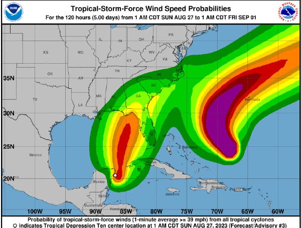
The tropical depression that formed in the Gulf of Mexico is expected to develop into a tropical storm on Sunday, according to the National Hurricane Center.
As of the latest update at 5 a.m., the center of Tropical Depression 10 was situated approximately 30 miles south-southeast of Cozumel, Mexico.
The depression had sustained winds of 35 miles per hour, accompanied by higher gusts, and was moving southwards at a speed of 5 miles per hour.
In the news: Florida Gov. DeSantis Issues State Of Emergency For 33 Counties Ahead Of Storm, Invest 93L
Tropical storm warnings have been issued for the Yucatan Peninsula of Mexico, covering the area from Tulum to Rio Lagartos, which includes Cozumel.
Additionally, a tropical storm warning has been issued for Pinar Del Rio. A tropical storm watch is also in effect for the Isle of Youth in Cuba.
Forecasters anticipate that the system will gain speed as it moves in a north-northeast direction over the eastern Gulf of Mexico, likely occurring on Monday.
It’s important for people in the affected regions to stay updated on the weather conditions and follow any guidance or advisories issued by local authorities and meteorological agencies to ensure their safety.
According to the forecasters at the National Hurricane Center (NHC), the tropical depression in question is anticipated to strengthen over the next few days. It’s expected to evolve into a tropical storm by Sunday and further intensify into a hurricane by Tuesday.
In the news: Pasco County Sandbag Stations Available – Dade City Location Added
Tropical Depression Ten is also predicted to bring significant amounts of rainfall to various areas. In particular, it’s projected to result in rainfall accumulations of approximately 2 to 4 inches across parts of the eastern Yucatan Peninsula. Some isolated areas might experience even higher rainfall amounts of up to 10 inches.
Furthermore, the western parts of Cuba are likely to witness rainfall amounts of around 3 to 6 inches, with certain isolated areas potentially receiving up to 10 inches of rainfall. This could potentially lead to issues like flash flooding, urban flooding, and landslides in the affected regions.
While there may not be any watches or warnings issued for the Tampa Bay area at the moment, it’s significant to note that the forecast track for the storm indicates a potential strengthening into a Category 1 hurricane. The forecast cone also suggests that areas from Pinellas County and further north could be affected, with the time frame being from Tuesday night into Wednesday morning.
In the news: St. Petersburg On Track To Distribute 5,000 Sandbags Saturday – More Locations Opening
Given the uncertainty that can be associated with tropical systems, it’s wise for residents in the Tampa Bay area and those in the potential affected regions to remain vigilant, closely monitor updates from trusted weather sources, and be prepared for any changes in the forecast.
Android Users, Click To Download The Free Press App And Never Miss A Story. Follow Us On Facebook and Twitter. Signup for our free newsletter.
We can’t do this without your help; visit our GiveSendGo page and donate any dollar amount; every penny helps

