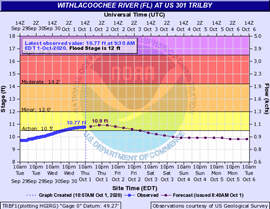
HERNANDO COUNTY, Fla. – The Withlacoochee River is currently at or approaching action stage. While the river level is not expected to reach minor flood stage at this time, some additional rise is expected over the next few days. Residents along the river are urged to stay informed, review emergency plans, and be prepared to take action to protect personal property, if necessary.
Withlacoochee River observations as of Thursday, October 1, 2020 at 9:30 a.m.
- Trilby is at 10.76 feet; action stage is 10.5 feet; minor flood stage is 12 feet.
- Croom is at 7.64 feet; action stage is 8 feet; minor flood stage is 9 feet.
ACTION STAGE
The stage which, when reached by a rising stream, represents the level where the National Weather Service or a partner/user needs to take some type of mitigation action in preparation for possible significant hydrologic activity.
Residents in and around the areas of Lacoochee, Talisman Estates, Riverdale, and River Height Estates are urged to prepare for possible action.
5-DAY TROPICAL WEATHER OUTLOOK
There are currently two areas of activity:
1. A large, disorganized tropical wave over the western Caribbean is likely to become a tropical depression near the Yucatan Peninsula this weekend or early next week. While this system is currently not forecast to have direct impacts to Florida, additional moisture will prolong the heavy rainfall threat in South Florida. This system has a 40% (medium) chance of formation during the next 48 hours, but a 70% (high) chance during the next 5 days. This system should continue to be monitored. The next name is Gamma.
2. Another large, disorganized tropical wave near the Lesser Antilles will move into the Caribbean later today or tonight. Conditions may become more favorable for development when the system reaches the central or western Caribbean early next week. This system has a 0% (low) chance of formation during the next 48 hours and a 20% (low) chance during the next 5 days. This system may need to be monitored heading into next week.
RECOMMENDED ACTIONS
- Residents living along the river and in low-lying, flood prone areas are urged to closely monitor river levels and take precautions as needed to protect life and property. Be prepared to move to higher ground if necessary.
- Monitor river gauges at: http://water.weather.gov/ahps2/index.php?wfo=tbw
- Do not drive through standing water. Turn around, don’t drown. Take this opportunity to refresh your emergency supply kit. For more information, visit http://www.HernandoCounty.us/EM


