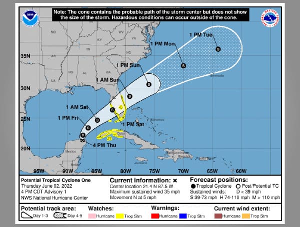
The National Hurricane Center is issuing advisories on Potential Tropical Cyclone One near the Yucatan Peninsula.
At 4:00 pm, the disturbance was moving toward the north near 5 mph (7 km/h) and this motion is expected to continue tonight. A turn toward the northeast is expected on Friday, and a faster motion toward the northeast is expected Friday night and Saturday.
On the forecast track, the system should move across the southeastern Gulf of Mexico through Friday night, and then move across the southern and central portions of the Florida Peninsula on Saturday.
A Tropical Storm Watch has been issued for the west coast of the Florida peninsula south of the Middle of Longboat Key and for the east coast of the Florida peninsula south of the Volusia/Brevard County line, including Lake Okeechobee.
A Tropical Storm Watch has been issued for all of the Florida Keys, including the Dry Tortugas and Florida Bay.
The government of Cuba has issued a Tropical Storm Watch for the Cuban provinces of Matanzas, Mayabeque, La Habana, Artemisa, and Pinar del Rio, and the Isle of Youth.
Visit Tampafp.com for Politics, Tampa Area Local News, Sports, and National Headlines. Support journalism by clicking here to our GiveSendGo or sign up for our free newsletter by clicking here.
Android Users, Click Here To Download The Free Press App And Never Miss A Story. Follow Us On Facebook Here Or Twitter Here.
Copyright 2022 The Free Press, LLC, tampafp.com. All rights reserved. This material may not be published, broadcast, rewritten, or redistributed.

