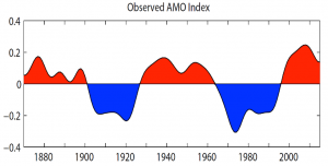
3 Atlantic Warm Water Cycles Since 1875

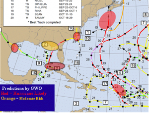
GWO’s Hot-Spot Predictions 2023
2024 Atlantic Hurricane Season – will be very active with 20 Named Storms and 6 landfall Hot-Spots.
TAMPA-OCALA, FLORIDA, UNITED STATES, February 1, 2024 /EINPresswire.com/ — The Atlantic Hurricane Seasons have been extremely active since 2016 – and will continue to be abnormally active for the next several years. This is not due to a global warming cycle – but instead – it is due to the naturally occurring Atlantic Multi-decadal Oscillation (AMO) that enhances a cyclical ClimatePulse Cycle.
The AMO is a naturally occurring warm ocean water cycle that recurs about every 70 years (there have been 3 AMO cycles since 1875). The Atlantic Ocean Basin (which includes the Caribbean and Gulf of Mexico) – entered the warmest portion of the current AMO Cycle in 2016, and this is why there have been so many hurricanes.
During the current AMO warm ocean cycle, the United States has experienced 40 named storms making landfall, with 20 of them being hurricanes – 9 of which were major hurricane landfalls. This very active hurricane cycle – will likely continue for another 10 years.
Global Weather Oscillations (GWO) utilizes ClimatePulse Technology for predicting where the landfall Hot-Spots will occur, and the predictions are very accurate predictions months in advance. The predictions prepared by Professor David Dilley – pinpoint the landfall Hot-Spots with an accuracy near 87%, and the predictions are split into 13 United States and Lesser Antilles zones. Detailed predictions are available via GlobalWeatherOscillations.com. or GlobalWeatherCycles.com.
What Should We Expect in 2024
An average hurricane season has 12-13 named storms and 6 hurricanes. The combination of the AMO warm ocean water cycle, favorable atmospheric conditions, and the enhanced ClimatePulse Cycle – will provide favorable conditions for a very active and destructive hurricane season in 2024.
Professor David Dilley is predicting 20 named storms, 8 hurricanes with 3 to 4 of them being major hurricanes. The United States and Caribbean will have 6 Hot-Spots with 3 to 4 United States hurricane landfalls expected, and 1 or 2 in the Caribbean. In addition, there is the potential for 1 or 2 major hurricane landfalls.
GWO and Professor Dilley invite you to join one of our (free) preseason Outlook Webinars. During the season Global Weather Oscillations and Professor David Dilley also conduct weekly hurricane outlook webinars that look 2 weeks into the future) and tracking webinars for clients when a hurricane will likely develop and have a landfall. The tracking webinars are typically initiated 8 to 15 days prior to its landfall.
Professor David Dilley
Global Weather Oscillations
+1 352-789-4461
email us here
Visit us on social media:
Twitter
LinkedIn
